Where did the Vikings overwinter in Thanet?
Search page
Search within this page here, search the collection page or search the website.
Grace Conium Parsonage: KAS PhD student introduction
Mrs Allen: The woman who kissed the hand of the Duke of Wellington as he died
Gordon Taylor
The earliest Viking attack on England occurred in 789 AD when they landed at Portland in Dorset. More notably, they attacked the Lindisfarne monastery in Northumbria in 793 AD and later targeted one at Iona. It is possible that earlier raids went unrecorded. Following the raids, the Vikings collected their spoils and returned to their homelands in Norway and Denmark.
It is known that the Vikings first overwintered in England on the Isle of Thanet in 850/851 AD. However, the exact location of their camp remains unknown. I have been curious about this for some years - how can I find out? It is likely that they chose a defensible site within view and easy reach of their ships on the coast. They probably built a defensive fence or ditch and erected wooden huts or leather tents. There would have been numerous fires for cooking and warmth, despite southeast England having milder winters compared to the Vikings’ homelands.
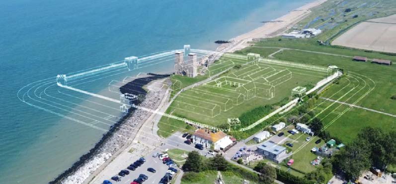
Archaeological evidence of the “Vikings’ massive mobile encampments has been discovered at Torksey in Lincolnshire and at Aldwark in Yorkshire” (English Heritage). It is possible that the Viking encampment in Thanet was located on the north coast, which may have eroded away over the past 1,170 years. Half of the Roman fort at Reculver has suffered a similar fate (see Fig 1). Fort Hill in Margate likely extended northwards and could have been an ideal site, but it is impossible to ascertain for certain. Steve Villette (IOTAS) suggested the area around the windmill at Drapers Mill school as a possible location, although it may have been quite far from the coast 1,170 years ago. He also mentioned that the estuary of Margate sands, which was fed by two streams, would have provided safe anchorage for the Vikings, enabling them to haul their ships inland.

The Torksey Viking camp from 872/3 AD was situated on the River Trent, 13 km northwest of Lincoln. The exact location remained unknown for many years but has recently been archaeologically investigated. An article in Current Archaeology online (August 2023) reveals that a Viking army on the move may not leave many archaeological traces. However, upon excavation, a large V-shaped ditch was discovered 4m wide and deep. Additionally, it was found that the camp reused the Mercian royal shrine of St Wigstan as a gatehouse. The D-shaped enclosure covered an area of 1.46 hectares (equivalent to 3.6 acres or 14,500 square meters).

I have recently become fascinated by an embankment on a new housing estate located on the former Holy Cross school grounds’ southern boundary. The embankment is approximately three meters high and best observed from Merrivale Heights off Dumpton Park Drive. It sits on a steep circular bluff towards Dumpton, including Bradstow School. The embankment is truncated by the railway line between Broadstairs and Dumpton to the west, and it gradually fades to the east, even though the land rises steeply there, possibly being the remnant of a ditch. On an O.S. map from 1899, the 100-foot contour depicts the round hill overlooking Louisa Bay.
Using a present-day Historic England Search map, which shows the bank, I realised that if continued, the line would enter the grounds of Bradstow School on their southwest corner. I had to check it out! Mr. Mike Kemlo of the school kindly gave me escorted access to the boundary wire (behind an acoustic screen). Despite the disturbed ground and bushes, it was clear that the embankment did not continue into their grounds, or if it once did, it was levelled long ago. The land drops steeply there to Dumpton Park Drive.

The bank in question likely existed during most, if not all, of the time that the Holy Cross school was present. The school was built in 1930, served as a hospital during WWII, reopened in 1947, and became the school we remember in 1962. The trees and bank could have appeared during one of these periods. The houses below the bank on Ellington Way came on the market in 2014. By viewing the Lidar map on our website, we can see the trees but no other clues. However, interesting rectangular marks exist on the land where the houses have been built.
Unless Viking artefacts, fire debris, organic, or other findings are discovered in the future, we can only speculate on where they might have camped. The north and east Thanet coasts would be unlikely, as ships would be vulnerable to winter gales. Therefore, the Ramsgate and Wantsum areas would be favourites for docking the vessels. Looking at a topographic map of Thanet, we find that Ramsgate Harbour has two areas of high ground to the west (Westcliff Road) and northeast (Bellevue Road), which could have been suitable. Unfortunately, both places are now built upon.

Depending on the navigability of the Wantsum Channel in the 9th century, Minster, or the high ground of the present Manston airport, would have made an excellent base with clear views of their ships.

This concludes the need for further research to identify the Vikings’ overwintering location on Thanet. I hope this short piece ignites the curiosity of future generations of archaeologists, historians, and landscape surveyors, encouraging them to delve deeper into this intriguing subject.
